Monday, 30 December 2013

BLACK TOR


    The area surrounding Black Tor has in many respects been neglected by both antiquarians and archaeologists over the years and before starting the survey work here it was believed that apart from a small lode-back tinwork very little else would be encountered.  As the survey progressed it soon became apparent that in the first place the tinwork was much more extensive than had been previously appreciated. In addition, remains of prehistoric date, together with those associated with stone quarrying and splitting and second world war training have survived.  
The survey work at Black Tor has revealed a complex multi-period archaeological landscape in which industrial activity appears to have played a prominent, although not exclusive part.   The earliest activity appears to relate to the prehistoric period and there are a number of features which may belong to this time.  The first are four enclosures, none of which is complete.  Three of these lie on the upper slopes of the hill and the fourth lies adjacent to the valley bottom.  None of these enclosures appear to be associated with round houses, although the possibility of them having once contained timber structures cannot be entirely ruled out.  However, given their location above the known settlement distribution, it does appear more likely that they represent animal enclosures in which animals being released onto the open moorland were corralled. 
            Three discreet areas of tinwork earthworks survive on the sides of the hill, whilst in the valley below there is an extensive alluvial streamwork and two mills in which the tin was crushed and processed.  The three tinworks survive as lines of pits cutting into the back of the lodes being explored or exploited.  In later years Dartmoor's industrial workers turned to Black Tor again - this time in the search of stone for building purposes.  Stone extraction in the area was always on a small scale, with surface stone being dug up and carted away leaving small distinctive hollows. 
The full survey report on the archaeology at Black Tor, Meavy Valley, Dartmoor was originally published in 1997 and is now available online. The report can be viewed here.    


Sunday, 22 December 2013


STANLAKE STONE ROW


The stone row at Stanlake on Dartmoor lies just inside the historic fields associated with Stanlake Farm and although now partly buried beneath a substantial field boundary it still forms an obvious visual landmark.  The row leads from NGR SX57217155 to SX57007137, measures 294m long and includes at least 57 visible stones.  Its north eastern end is denoted by a substantial blocking stone and its lower south western end by three funerary cairns.  The row lies in an area containing abundant field evidence relating to prehistoric activity, lying as it does between two major settlements and within 460m of three other rows.
The stone row was surveyed during 1996 as part of the Meavy Valley Project and the results published the following year. The full report on this stone row can be viewed here.


Friday, 13 December 2013

BLACK TOR FALLS TIN MILLS


    The two tin mills lying immediately below the picturesque Black Tor waterfall are situated a short distance beyond the historic fields associated with Stanlake Farm.  The mills are situated next to the River Meavy and may be found on either side of the pond formed by the waterfall. These mills were originally built to house the crushing machinery needed by pulverize the tin ore mined from the nearby tinworks.  Several mortar stones on which tin ore was crushed by water-powered stamps still survive, as do a number of especially prepared stones on which the water wheel axle rotated.  To the south of the mill on the right bank of the river are a series of earthworks and structures which denote the dressing floor where the tin ore from the stamps was washed.  One of the leats which served  the mills is still clearly visible hugging the foot of  a steep slope.  This slope together with an array of linear earthworks were formed during earlier streamworking operations within this part of the Meavy Valley.  The mill on the left bank, in particular, is clearly built upon earlier streamwork earthworks.  Since the streamwork is earlier than the mills it is unlikely to be the source of the tin ore crushed at this place.  Although tin mills are known to have crushed ore found during streaming operations they are more usually built to serve nearby mines where all of the ore had to be pulverized before the valuable tin could be recovered.  Two main areas with surviving tin mines lie relatively close to the mills at Black Tor Falls.  The first is around Black Tor itself where at least three separate groups of lode-back pits may have been a source of the tin ore crushed at the mills.  The second group of tinworks which may have sent ore to the mills lie on the western slopes of Hart Tor where a number of lodes appear to have been exploited using lode-back pits and openworks.  
The archaeological survey report produced in 1997 can be found here. 

Plan of the mills 


Thursday, 5 December 2013


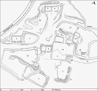
STANLAKE FARMSTEAD


   The surviving historic farmstead at Stanlake lies just north of the Burrator Forestry plantation at NGR SX 569709.  A complex array of earthworks and fragments of walling protrude from the ground giving the impression of a once extensive and prosperous farm.  The farm itself extends over both sides of the River Meavy, although most of the land lies together with the farmstead on the western side of the river.
       The farmstead was originally surveyed in detail by R.G. Haynes in 1967 and a copy of his plan forms part of his unpublished work Deserted Sites on Dartmoor which is available in Plymouth Museum.  Haynes's survey shows most of the features identified within the new plan, although a number of additional earthworks were identified and other details added during the fieldwork carried out in 1996. 
A full version of the report originally published in 1997 is now available online and can be found here.


Friday, 29 November 2013

Stanlake prehistoric settlement


Between 1996 and 1998 a programme of archaeological survey work was carried out within the Meavy Valley on Dartmoor, Devon, England. The results of this work were published as a series of ten short reports. The first report dealt with an impressive prehistoric settlement at Stanlake.  

The prehistoric settlement at Stanlake lies within the historic fields belonging to the farm of the same name.  The settlement lies on a south facing slope at an altitude of between 310m and 335m and overlooks the River Meavy.  Despite its situation within later fields, the settlement is well preserved and a particularly informative group of earthworks and other structures remain essentially intact, although some have been altered and adapted during the historic period.  The report is primarily concerned with the prehistoric settlement, although the surviving historic archaeology is also of considerable interest and is also examined.
To read the full report please click here.