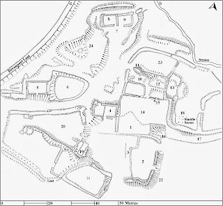
STANLAKE FARMSTEAD
The
surviving historic farmstead at Stanlake lies just north of the Burrator
Forestry plantation at NGR SX 569709. A
complex array of earthworks and fragments of walling protrude from the ground
giving the impression of a once extensive and prosperous farm. The farm itself extends over both sides of
the River Meavy, although most of the land lies together with the farmstead on
the western side of the river.
The farmstead
was originally surveyed in detail by R.G. Haynes in 1967 and a copy of his plan
forms part of his unpublished work Deserted Sites on Dartmoor which is available in Plymouth Museum
A full version of the report originally published in 1997 is now available online and can be found here.

No comments:
Post a Comment